Causal modelling of Analytical Hierarchy Process in uitable Disposal Sites for drilling- waste produced from Oil and Gas Fields
Mohamad Amin Daneshfar*, Mehdi Ardjmand
Department of Chemical, Islamic Azad University, South Tehran Branch, Chemical Engineering Department, Tehran, Iran
*Corresponding author: Daneshfar MA, Department of Department of Chemical, Islamic Azad University, South Tehran Branch, Chemical Engineering Department, Tehran, Iran; E-Mail: mdaneshfar38@gmail.com
Received date: July 14, 2020; Accepted date: August 20, 2021; Published date: August 30, 2021
Citation: Daneshfar MA (2020) Causal modelling of Analytical Hierarchy Process in uitable Disposal Sites for drilling- waste produced from Oil and Gas Fields. J Environ ResVol: 5 No: 5.
Abstract
Inflammation This study aims to selecting of Suitable disposing drilling waste sites produced from oil and gas fields. Khark and Lavan islands in Persian Gulf were selected as case study. In this study, effective and causal criteria of suitable disposing site selection for drilling wastes were selecting and prioritizing by the expert team. Data analysis performed using Analytical Hierarchy Process (AHP) and Fuzzy DEMATEL methods. Results indicated that among the required sub-criterion for selecting the suitable waste disposing site on Khark and Lavan islands, distance from city centers and population per weights (0.220, 0.229), distance from roads per weights (0.170, 0.161), distance from rivers per weights (0.139, 0.137) and distance from the airport per weights (0.106, 0.108) are most important sub-criteria respectively. These mentioned sub-criterions have the greatest impact on the selection of suitable disposing sites on these islans. Fuzzy DEMATEL results indicated the effective criteria is distance from city centers which correspond with the results of hierarchical analysis. The results of spatial analysis indicate that the lands located south of Khark island (site1 and 3) and the central lands of Lavan Island (site1, 2, 3, 4, 5) are very good places to evacuate waste.
Keywords: Spatial Analysis; Drilling waste; Analytical hierarchy process; Fuzzy; DEMATEL
Introduction
One of the permanent side effects in the drilling of oil and gas wells is the process of waste production. The waste contains oily materials so in the absence of a suitable locating for disposing, it will have adverse environmental effects. The existence of suitable pattern for locating waste disposing is necessary and should be chose as the best place for waste disposal. This model should be design to bring the fewest environmental impacts and has the technical and economic feasibility. Environmental impacts, technical, economic, social and cultural issues are measuring by different criteria and dimensions that comparing criteria impossible in earlier stage. Therefore; a suitable model for decision-making is a model that can weigh different criteria and would calculate them in order to provide a comparative advantage. Multi- criterions decision models have this capability and will be useful in this regard. These models are appling to multidimensional issues that by quantifying qualitative criteria, allow for the comparison of different processes. The AHP methodology is one of the useful methods for working with multiple objectives and criteria in decision-making. The purpose of this method is to identify the best option and to determine the ranking of options by simultaneously taking into account all decision-making criteria. This method involves various options in decision- making and it is possible to analyze the sensitivity of the criteria and sub-criteria. The method is basing on a paired comparison that facilitates judgment and computation that indicates the degree of compatibility and incompatibility of the decision (Al Harbi, 2006). In addition to selecting the best option in different sectors, proper location for waste disposing in the provision of a waste management model is of great importance. The choice of multiple factors leads to multiple layers of information and leads decision makers unconsciously towards a system that, in addition to high precision, is in terms of the speed of operation and the ease of doing operations at a high level. One of the best solutions in this area is the use of GIS. This system is nowadays useful in earth sciences, and all the disciplines that derive part of their data from the Earth are users of the System. Integrating the AHP and GIS is a powerful tool for
Selecting the suitable waste disposing site. Because the AHP provides ranking and prioritization of the potential sites studied based on a variety of criteria, GIS provides effective management and representation of the data (A Badri, 1999; Sener et al., 2011). Several studies have carried out in recent years to select the best locating waste disposing through the AHP and GIS. Most of this research is about selecting disposal sites for urban and industrial wastes, and in these studies, all the criteria for selecting the sites have not interfere. It should be noted that each of the economic, technical, social, cultural and environmental parameters alone is not involved in choosing the best disposal sites. A waste disposal system must simultaneously consider all criteria. It can be said that to date, there has not been a proper model for the disposal of drilling waste produced from oil and gas wells, especially in offshore areas. This study, for the first time, has addressed this issue. Optimal Collection and Transportation System for Solid Waste in Allahabad City was selecting by using GIS. In this research, a simple optimal routing model is proposed to achieve the minimum transportation cost, distance, time, and number of vehicles (Chaudhary et al., 2019). The Urban Solid Waste Management of the city of Doha, Qatar, was selecting by using the GIS method. Waste management in the sense, to make the waste collection sustainable by providing or reallocating the bins according to waste generation and population density utilizing GIS application. The results acquired after analysis shows that there is notable minimization or saving of time after re-distributing the bins (Balakrishnan et al., 2019). The burial site of the city of Behbahan, Iran, was selecting by using the AHP and GIS methods. Based on the results of this study, 38% of the studied area was evaluating for proper burial. Finally, five sites for burial were proposed (Ghaedrahmat et al., 2017). The landfill site of the Babylon area of Iraq was selecting by combining the AHP and GIS. In this research, two sites with a total area of 8204 and 9153 km were selecting according to environmental issues (Chabuk et al., 2016). In order to select the burial site, conducted a research in the Palestinian Gaza Strip using the AHP and GIS. Based on the results of this
Study, 5.5% of the total area for the burial sites was highly rated (Elbaba et al., 2015). The burial site of the city of Saqez, Iran, was selecting using the AHP and GIS. Based on the results of this plan, a site with a total area of 74 hectares was found. This site will be able to receive 130 tonnes of waste per day over the next 20 years (Shahabi et al., 2014). The landfill site without the danger of the region of Pelug, Macedonia was selected using AHP and GIS. Accordingly, if the environmental and economic objectives are valued the same, at least the suitable level of landfill is 1%, and if the economic objectives are higher then this is 1.8% of the total production (Doneska et al., 2012) .AHP and GIS methods used to determine the suitable waste landfill location in the Senerikent-Uluborlu region of Turkey. According to the results, 96.3% of the land in this area was poor, 1.6% was partly suitable and 2.1% was suitable from sanitation point of view (Sener et al., 2011). The solid waste landfill site was selecting by combining the AHP and GIS in Karaj, Iran. Based on the results of this project, 6% of the studied area was evaluating for the landfill site (Moeinddini et al., 2010). Using the AHP and GIS, selected the landfill site in Beiging, China. According to the results of this research, three sites with excellent, good and inappropriate options for burial were introduced (Wang et al., 2009). Waste from drilling operations of oil and gas wells, such as waste produced by other industries, in case of inappropriate disposing can lead to many problems. With the increasing of drilling operations development, the waste produced by this type of activity will also increase, so considering the necessary measures to reduce the environmental, economic, social and cultural problems arising from drilling operations is necessary. No specific scenario has made for the locating of the disposing of drilled wastes produced in Persian Gulf on Khark and Lavan islands yet; the purpose of this research is to locating the suitable disposing place of drilled wastes produced in Persian Gulf on Khark and Lavan islands by using the AHP and GIS.
Materials and Methods
Case study
The Persian Gulf is at 24 to 30 degrees and 30 minutes north latitude, and 48 to 56 degrees, and 25 minutes east along the Greenwich meridian. The gulf has an area of about 251,000 square kilometers in the Middle East region along the Oman Sea. Due to the close proximity of oil and gas fields in the west and east of the Persian Gulf to Khark and Lavan Islands, waste generated from drilling operation in these areas is transfered to these two islands.
Khark Island
Khark Island is located 29 degrees 15 minutes north latitude and 50 degrees and 20 minutes east longitude. The island is locating about 76 km northwest of Bushehr and 30 km from the port of Genaveh and is considering part of the Bushehr province. Khark is 8 km long and 4 km wide and its average height is about 3 m from the sea level (IOOC, 2018).
Lavan Island
Lavan Island is one of the islands of Hormozgan province in the Persian Gulf. It has approximately 23.5 km longth and 4.8 km width (IOOC, 2018).
Selection of criteria
Various factors are involved in selecting the suitable site for drilling waste disposing in Khark and Lavan islands. These effective factors include distance from industrial areas, industrial building, slope, elevation, distance from oil and gas lines, oil storage, oil rig, distance from roads, distance from urban and population centers, land covering, distance from airport, fault line, Vegetation, distance from rivers and geology. Each of these layers is briefly discussing below.
2.2.1. Distance from industrial areas and industrial building
The drilling waste should be disposed in a place away from industrial areas and industrial buildings. The proximity of waste disposal to industrial centers and industrial buildings, in addition to interfering with manpower and transportation, jeopardizes the landscape's beauty
of these places. According to the Iran department of Environment (DOE), the minimum distance between the waste disposal site and industrial areas and buildings should be 1000 meters (DOE, 2018).
2.2.2. Slope
In the location discussions, the slope parameter is important from an environmental and economic point of view. Economically, the construction of waste disposing sites in sloping areas is inappropriate and increases excavation and embankment costs. The bottom of the slope will prevent the flow of leachate from being surface and underground to water resources and other areas. According to the DOE, in the design of the site of disposal, dewatering processes should be do in such a way that the lowest part of the disposal site is at least 2 meters from the long-term groundwater level of the area (DOE, 2018).
2.2.3. Elevation
The height difference parameter is important in order to reduce the costs of constructing the disposal site of digging waste. When constructing a disposal site for drilling waste, pathways are creating to create the original waste collector. One of the important features of this route is shortening and facilitating the entry of waste to the site of evacuation in gravity. Otherwise, the cost of waste disposal should be considering (DOE, 2018).
2.2.4. Distance from oil and gas lines, oil storage and oilrig
According to the DOE, the minimum distance between the waste disposal site and oil and gas lines, oil storage and oilrig should be 500 meters (DOE, 2018). Because the two islands Khark and Lavan have oil and gas facilities, the distance from the mentioned centers should be, observe.
2.2.5. Distance from roads
In general, in order to reduce costs, a waste disposing site should be selected which is near the main roads. According to the DOE, the minimum distance between the waste disposal site and roads should be 300 meters (DOE, 2018). In this research, due to the limited area of the islands and a constant value, it should be considered as a permanent place away from roads to disposing of waste drilling. This is a permanent disaster and, in addition to the beauty of the island's landscape, it is preventing from re-routing drilling waste to other locations.
2.2.6. Distance from city and population centers
In the location of drilling waste disposing, the distance from the city centers and the population from the environmental and economic point of view are examining. The waste disposing site should be located far from city and population centers due to bad conditions and unpleasant odors. Economically, the excessive distance of the chosen location will increase transportation costs. According to the DOE, the minimum distance between the waste disposal site and city and population centers should be 1000 meters (DOE, 2018).
2.2.7. Land covering
Land covering is the use of land to meet various human needs, including agricultural, industrial, residential land, and so on. In the case of chosing suitable places for waste disposal, we should consider that these regions are not other application such as agricultural uses. In order to locate waste, it should be note that land is not considering for waste disposing. The land covering information layers in this study includes vegetation covering, barren lands, road, city center, airport, rock, oilrig, industrial areas, building and oil storage. These applications have different values from the highest to the lowest value in determining the optimal waste disposal site.
2.2.8. Distance from airport
According to the DOE, the minimum distance between the waste disposal site and the internal and international airports should be 3000 and 8000 meters respectively (DOE, 2018). In the
Present study, the islands of Khark and Lavan are internal airports, and to comply with the rules and regulations for locating drill waste disposing.
2.2.9. Fault line
Failed fault areas are not suitable for waste disposal. First, the fault zones increase the permeability of the area and increase the movement of the lagoon in the ducts. Another view is that the locating of waste disposing as an engineering structure can be damage by the effects of fault-induced movements and threaten the health of the environment and human health. According to the DOE, The disposal site should not be located on the path and fault zone of the active faults and hidden faults. In addition, the disposal site should be 200 meters from the foreseeable range for earthquake hazards (DOE, 2018).
2.2.10. Vegetation
The vegetation parameter is used to maintain the value of land and prevent the destruction of forest and grassland ((pasture)) areas. The basis for classifying this parameter is the selection of the location for disposing of waste with the least adverse effect on vegetation. According to the DOE, the minimum distance between the waste disposal site and city and vegetation should be 1000 meters (DOE, 2018).
2.2.11. Distance from rivers
One of the important issues to consider in disposing location is the presence of surface waters in each area. Surface waters including lakes, rivers, stream and so on should be identify and reviewed. The waste disposing site should not be in an environment where there is a risk of water pollution. According to the DOE, the minimum distance between the waste disposal site and rivers should be 1000 meters (DOE, 2018).
2.2.12. Geology
One of the characteristics of rock is the rock mass permeability. The rock permeability is different according to the rock, and if the bonding between the constituent parts does not exist,
It is not appropriate to construct a waste disposal site. The particle size and low permeability are the features that raise their points in the location of waste spillage. Seams and gaps increase the permeability of the rocks to some extent and create constraints to create a waste disposing site. It is possible to construct a waste disposing site by creating favorable conditions from the point of view of geological engineering. According to the DOE, The construction of disposal mounds in valleys and areas with coarse-grained and porous bedrock, featherbeds, limestone and dentinite karstis, soluble gems and salt domes are prohibited (DOE, 2018).
2.3. Analytical hierarchy process (AHP)
AHP is a multi-criteria decision-making method based on a specific objective that using of different criteria and sub-criteria. After considering each of them, one can choose among the options for selecting a specific objective or ranking other options (Mahmood et al., 2017). This method was originally developing by Thomas Al-Saati in the 1980s. The AHP consists of three main steps as follows:
2.3.1. Build a hierarchy
The first step in the AHP is to draw a graphical representation of the problem in which the objective, criteria and sub-corrections are suitable for achieving the desired objective and options. In fact, different levels of analysis are depicting hierarchically and graphically at this stage. The first level is objective. At the second and third level, there are criteria and sub- criteria that can be achieve with the objective. The fourth level includes options available (Roig Tierno et al., 2013).
2.3.2. Paired comparisons
In the process of analyzing the hierarchy, the elements of each level are comparing and weighed relative to the other level (two to two). A paired comparison is performing as the value of the row element relative to the column element and for the valuation, a spacing of 1 to 9 is usually using in accordance with Table 1. Higher value was giving the greater importance and priority
Of the line element than the column. Therefore, the value of nine is more important and the value of one indicates the same preference. It should be noted that the paired comparison matrix is an inverse matrix, which means that if the element A is preferred to element B equal to N and if the element B is preferred to element (A), equal to 1 / N.
| Intensity of importance | Description |
|---|---|
| 1 | Equal importance |
| 3 | Moderate importance |
| 5 | Strong or essential importance |
| 7 | Very strong or demonstrated importance |
| 9 | Extreme importance |
| 2 ,4 , 6 , 8 | Intermediate values |
2.3.3. Calculation the inconsistency rate (IR)
The inconsistency rate in the AHP is an indicator that shows the consistency of comparisons. This rate indicates the degree of accuracy and accuracy of the values in the pair comparison. If the rate is less than 0.1, the values and comparisons can be considered proper and correct. Otherwise, the pairings should be re-evaluating or corrected. The IR is calculating by
Inconsistency index (II) according to equation (1).
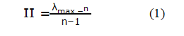
In this equation, λmax is a special vector element and n is the number of criteria. The special vector contains the following steps:
Multiplication of the matrix in the vector of weight
Divide the numbers obtained from the above step on the weight of the relevant parameters
The average of all the numbers obtained
λmax Must be calculating for the number of criteria and for all of them, and then their sum is obtaining in equation 1, (II). Another required index is a Random index (RI) that is proportional to the number of criteria in Table 2. Finally, the IR is calculating from Equation 2.
| n | 2 | 3 | 4 | 5 | 6 | 7 | 8 | 9 | 10 | 11 | 12 | 13 | 14 | 15 |
| RI | 0 | 0.58 | 0.9 | 1.12 | 1.2 | 1.32 | 1.41 | 1.45 | 1 | 1.5 | 1.5 | 1.6 | 1.6 | 1.6 |
Table 2: Random index for a number of different criteria (Saaty, 1980)
Fuzzy DEMATEL
The Battle Memorial Institute developed the DEMATEL method in a study under the Zeno research core. The original DEMATEL model was used to achieve the appropriate approach to controversial phenomena at the global community level. The superior advantage of this model is in the analysis of causal relationships between a set of variables. The steps in this technique are as follows (Zareahmadabadi & Ghasemi, 2014; Shahi et al., 2018):
Designing a decision matrix
Calculation of fuzzy matrix of direct communication 3- Normalization of fuzzy direct communication matrix 4- Calculation of fuzzy general communication matrix 5- Drawing a causal diagram
6- Deffuzification of general communication matrices 7- Calculatation of internal communication matrix
Spatial Analysis
Locating in earth sciences is an operation in which a specialist by providing the needs, objectives and information of the status quo obtaining the best selection of the choices available for the intended use. The main purpose of locating is to ensure that the location of human activities is compatible with the environment in accordance with the facilities and constraints. Nowadays, using GIS (Çolak et al., 2016; Tokatli, 2017), efforts have made to locate more
Scientifically and realistically. This system is a coherent system of hardware, software and data that allows data entered into a computer, store, analyze, analyze, transmit and retrieve, and in the form of map information, a table and a model of geographical areas be publishing. In general, the steps to be taking to move geographic information are:
- Datermination of objective
- Datermination of model
- Datermination of criteria layers
- Criteria in the Geographic information system )GIS( environment
- Creation a two-in-two matrix and weighting criteria
- Calculations in the GIS environment based on the weight of each criterion
- Doing the analysis (Sener et al., 2006)
Hierarchy Causal Spatial
The current research is appling in terms of purpose, analytical-descriptive and it is performance. The purpose of this study was to determine suitable locating for the disposing of drilling waste produced in the Persian Gulf region on Khark and Lavan Islands. At first, theoretical foundations of the research were basing on documentary, library and referral to relevant organizations. Criteria, sub criteria and different options were selected by examining different standards, including standards for the environmental organization (DOE), as well as reviewing current methods and new technologies by looking at global practices according to the expert team (environment, geography, logistic, economic and petrolume experts). Accordingly, the hierarchical tree was depicted in different sections. The hierarchical tree mapping the disposing of waste from Persian Gulf region in Khark and Lavan islands is showing in Figure 1. Then these parameters were weighing and their information layers were prepared according to the calculated weights in the GIS environment. To determine the coefficient of importance (weight), the criteria and sub-criteria were weighting in a two-to-two
Matrix using the AHP method and EC software. Using the Weighted Linear Combination (WLC) method, the information layers were combging and eventually suitable areas for waste disposing were selecting.

Figure 1: Hierarchical tree in locating waste disposing on Lavan and Khark islansds
Results and discussion
Hierarchical model of waste disposing
Locating of waste disposing on Khark Island
The information layers (sub-criterion) in the GIS software were using to locate the evacuation of waste in Khark Island. Table 3 presents the results of classification, normalization, weight and rate of inconsistency of the sub-criterion affecting the locating of waste disposing in Khark Island. As shown in Table 3, the rate of inconsistency in all subcategories is less than 0.1, which indicates the consistency of the comparisons.
| Sub Criteria | Sub Criteria values | Sub Criteria Normalized values | Sub Criteria weight | Inconsis tency |
|---|---|---|---|---|
| <300 | 0.049 | |||
| Industrial building (m) | 300-600 | 0.079 | 0.068 | 0.023 |
| 600-900 | 0.144 | |||
| 900-1200 | 0.244 | |||
| <1200 | 0.483 | |||
| >5 | 0.44 | |||
| 10-May | 0.275 | |||
| Slope (m) | 15-Oct | 0.15 | 0.012 | 0.01 |
| 15-20 | 0.083 | |||
| <20 | 0.052 | |||
| >20 | 0.461 | |||
| 20-40 | 0.263 | |||
| Elevation (m) | 40-60 | 0.14 | 0.013 | 0.01 |
| 60-80 | 0.086 | |||
| <80 | 0.049 | |||
| >150 | 0.051 | |||
| Distance from gas lines (m) | 150-300 | 0.082 | ||
| 300-450 | 0.139 | 0.051 | 0.01 | |
| 450-600 | 0.269 | |||
| <600 | 0.459 | |||
| <300 | 0.047 | |||
| 300-600 | 0.079 | |||
| Oil storages (m) | 600-900 | 0.143 | 0.033 | 0.03 |
| 900-1200 | 0.242 | |||
| <1200 | 0.49 | |||
| <300 | 0.053 | |||
| 300-600 | 0.086 | |||
| Oil rig (m) | 600-900 | 0.139 | 0.041 | 0.02 |
| 900-1200 | 0.234 | |||
| <1200 | 0.488 | |||
| >200 | 0.525 | |||
| Distance from roads (m) | 200-400 | 0.242 | ||
| 400-600 | 0.124 | 0.17 | 0.03 | |
| 600-800 | 0.071 | |||
| <800 | 0.037 | |||
| >800 | 0.032 | |||
| Distance from city centers (m) | 800-1600 | 0.064 | ||
| 1600-2400 | 0.137 | 0.22 | 0.04 | |
| 2400-3200 | 0.291 | |||
| <3200 | 0.476 | |||
| <500 | 0.055 | |||
| Distance from industrial areas (m) | 500-1000 | 0.095 | ||
| 1000-1500 | 0.156 | 0.023 | 0.01 | |
| 1500-2000 | 0.269 | |||
| <2000 | 0.425 | |||
| Vegetation | 0.155 | |||
| Barren lands | 0.266 | |||
| Road | 0.044 | |||
| City center | 0.014 | |||
| Land covering | Airport | 0.019 | 0.087 | 0.07 |
| Rock | 0.214 | |||
| Oil rig | 0.122 | |||
| Industrial areas | 0.056 | |||
| Industrial building | 0.025 | |||
| Oil storages | 0.085 | |||
| <800 | 0.042 | |||
| Distance from airport (m) | 800-1600 | 0.07 | ||
| 1600-2400 | 0.14 | 0.106 | 0.04 | |
| 2400-3200 | 0.264 | |||
| < 3200 | 0.458 | |||
| > 200 | 0.052 | |||
| 200-400 | 0.083 | |||
| Fault line (m) | 400-600 | 0.15 | 0.02 | 0.01 |
| 600-800 | 0.275 | |||
| < 800 | 0.44 | |||
| < 50 | 0.06 | |||
| 50-100 | 0.095 | |||
| Vegetation (m) | 100-150 | 0.155 | 0.009 | 0.03 |
| 150-200 | 0.239 | |||
| < 200 | 0.451 | |||
| > 400 | 0.039 | |||
| Distance from rivers (m) | 400-800 | 0.07 | ||
| 800-1200 | 0.135 | 0.139 | 0.03 | |
| 1200-1400 | 0.241 | |||
| < 1400 | 0.515 | |||
| Khark Limston Formaton | 0.082 | |||
| Aghajari Formaton | 0.472 | |||
| Sand Beach | 0.05 | |||
| Geology | Marine Beds | 0.256 | 0.008 | 0.07 |
| Consolidated Beach Deposit | 0.139 |
Table 3: Results of categorization, normalization, relative weight and incompatibility rate of the sub-indicators affecting the locating of waste disposing in Khark Island
Using the results of Table 3 for each of the sub-criteria, a weighted map was prepared in order to obtain a proposed map for the disposing of waste in the final stage by integrating them. Figure 2 and 3 show the weights for information layers for disposing in Khark Island.

Figure 2: The weights for information layers for disposing of waste on Khark Island

Figure 3: The weights for information layers for disposing of waste on Khark Island
Weighing the sub-criteria through the AHP method in EC software was using to emphasize the importance of different layers of information. The results of the weighting of the sub-criterion in landing disposing in Khark Island, which apply to the final mapping, are presenting in Figure 1 in the supplemental file.
Locating of waste disposing on Lavan island
The information layers (sub-criterias) in the GIS software were using to locate the evacuation of waste in Lavan Island. TABLE 4 presents the results of classification, normalization, weight and rate of inconsistency of the sub-criterias affecting the locating of waste disposing in Lavan Island. As shown in TABLE 4, the rate of inconsistency in all subcategories is less than 0.1, which indicates the consistency of the comparisons.
| Sub Criteria | Sub Criteria values | Sub Criteria Normalized values | Sub Criteria weight | Inconsis tency |
|---|---|---|---|---|
| <300 | 0.055 | |||
| 300-600 | 0.082 | |||
| Industrial building (m) | 600-900 | 0.138 | 0.067 | 0.03 |
| 900-1200 | 0.239 | |||
| <1200 | 0.487 | |||
| >5 | 0.466 | |||
| 10-May | 0.29 | |||
| Slope (m) | 15-Oct | 0.123 | 0.012 | 0.01 |
| 15-20 | 0.075 | |||
| <20 | 0.046 | |||
| >10 | 0.485 | |||
| 20-Oct | 0.269 | |||
| Elevation (m) | 20-30 | 0.122 | 0.015 | 0.03 |
| 30-40 | 0.077 | |||
| <40 | 0.047 | |||
| >150 | 0.046 | |||
| Distance from gas lines (m) | 150-300 | 0.082 | ||
| 300-450 | 0.144 | 0.055 | 0.03 | |
| 450-600 | 0.28 | |||
| <600 | 0.449 | |||
| <300 | 0.047 | |||
| 300-600 | 0.085 | |||
| Oil storages (m) | 600-900 | 0.148 | 0.03 | 0.01 |
| 900-1200 | 0.252 | |||
| <1200 | 0.468 | |||
| >150 | 0.043 | |||
| Distance from oil lines (m) | 150-300 | 0.067 | ||
| 300-450 | 0.119 | 0.04 | 0.02 | |
| 450-600 | 0.316 | |||
| <600 | 0.455 | |||
| > 200 | 0.544 | |||
| 200-400 | 0.225 | |||
| Distance from roads (m) | 400-600 | 0.127 | 0.161 | 0.03 |
| 600-800 | 0.066 | |||
| <800 | 0.038 | |||
| >800 | 0.034 | |||
| Distance from population centers (m) | 800-1600 | 0.072 | ||
| 1600-2400 | 0.147 | 0.229 | 0.03 | |
| 2400-3200 | 0.274 | |||
| <3200 | 0.473 | |||
| <500 | 0.052 | |||
| Distance from industrial areas (m) | 500-1000 | 0.089 | ||
| 1000-1500 | 0.152 | 0.024 | 0.01 | |
| 1500-2000 | 0.264 | |||
| <2000 | 0.445 | |||
| Vegetation | 0.173 | |||
| Barren lands | 0.298 | |||
| Road | 0.052 | |||
| Land covering | Population center | 0.016 | 0.084 | 0.07 |
| Airport | 0.023 | |||
| Rock | 0.234 | |||
| Industrial areas | 0.068 | |||
| Industrial building | 0.029 | |||
| Oil storages | 0.106 | |||
| <800 | 0.034 | |||
| 800-1600 | 0.072 | |||
| Distance from airport (m) | 1600-2400 | 0.14 | 0.108 | 0.02 |
| 2400-3200 | 0.281 | |||
| <3200 | 0.473 | |||
| >9000 | 0.053 | |||
| 9000-10000 | 0.094 | |||
| Fault line (m) | 10000-11000 | 0.155 | 0.018 | 0.01 |
| 11000-12000 | 0.266 | |||
| <12000 | 0.432 | |||
| <50 | 0.062 | |||
| 50-100 | 0.092 | |||
| Vegetation (m) | 100-150 | 0.158 | 0.01 | 0.02 |
| 150-200 | 0.246 | |||
| <200 | 0.442 | |||
| >400 | 0.042 | |||
| 400-800 | 0.067 | |||
| Distance from rivers (m) | 800-1200 | 0.131 | 0.137 | 0.02 |
| 1200-1400 | 0.269 | |||
| <1400 | 0.491 | |||
| Geology | Plbk | 0.75 | 0 | |
| Jf | 0.25 | 0.008 |
TABLE 4: Results of categorization, normalization, relative weight and incompatibility rate of the sub-indicators affecting the locating of waste disposing in Lavan Island
Using the results of TABLE 4 for each of the sub-criteria, a weighted map was prepared in order to obtain a proposed map for the disposing of waste in the final stage by integrating them. Figures 2 and 3 in the supplemental file show the weights for information layers for disposing in Lavan Island.
Weighing the sub-criteria through the AHP method in EC software was using to emphasize the importance of different layers of information. The results of the weighting of the sub-criterias in landing disposing in Lavan Island, which apply to the final mapping, are presenting in Figure 4 in the supplemental file.
Fuzzy DEMATEL model of waste disposing
In order to evaluate the criteria for constructing a suitable location for disposal sites for drilling- waste produced from oil and gas fields, it is necessary to focus on causal criteria. Distance from city centers (3.95) and Distance from population centers (3.91), Distance from roads (3.89), Distance from rivers (3.86) and Distance from the airport (3.7) have the highest values among all criteria in the causal group. In addition, Distance from oil lines has the highest ri among causal criteria.
| ð??ð?? + ð?ð?? | ð??ð?? − ð?ð?? | Criteria Type | ð??ð?? | ð?ð?? | |
|---|---|---|---|---|---|
| Criteria | |||||
| Industrial building (m) | 3.65 | -1.03 | effect | 1.31 | 2.34 |
| Slope (m) | 3.57 | 0.18 | cause | 1.875 | 1.695 |
| Elevation (m) | 3.6 | -1.12 | effect | 1.24 | 2.36 |
| Distance from city centers (m) | 3.95 | -1.12 | effect | 1.415 | 2.535 |
| Distance from gas lines (m) | 3.2 | 1.04 | cause | 2.12 | 1.08 |
| Oil storages (m) | 3.1 | 0.42 | cause | 1.76 | 1.34 |
| Distance from oil lines (m) | 3.5 | 1.06 | cause | 2.28 | 1.22 |
| Distance from roads (m) | 3.89 | 0.41 | cause | 2.15 | 1.74 |
| Distance from population centers (m) | 3.91 | 0.22 | cause | 2.065 | 1.845 |
| Distance from industrial areas (m) | 3.4 | 1.09 | cause | 2.245 | 1.155 |
| Land covering | 3.3 | 0.31 | cause | 1.805 | 1.495 |
| Distance from airport (m) | 3.7 | 0.28 | cause | 1.99 | 1.71 |
| Fault line (m) | 3.63 | -0.78 | effect | 1.425 | 2.205 |
| Vegetation (m) | 3.62 | -1.42 | effect | 1.1 | 2.52 |
| Distance from rivers (m) | 3.86 | 0.2 | cause | 2.03 | 1.83 |
| Geology | 3.57 | -0.53 | effect | 1.52 | 2.05 |
Table 5: Fuzzy DEMATEL modelling result
Hierarchy Causal Spatial
According to the results, the distance from city centers (0.220) is the top priority and distance from the roads (0.170), distance from the rivers (0.139), distance from the airport (0.106), land covering (0.087), industrial buildings (0.068), distance from gas lines (0.051), oil rig (0.041), oil storage (0.033), distances from industrial areas (0.023), fault lines (0.020), elevation (0.013), Slope (0.012), vegetation (0.009), geology (0.008) are next in ranking respectively for the locating of waste disposal site in Khark Island. The inconsistency rate is 0.08, which indicates consistency of the comparisons. The parameters of distance from city centers, distance from roads, distance from rivers and distance from airport are considering more than other parameters in Khark Island. These results confirm the sensitivity of environmental and social-cultural criterion in disposing waste from the western regions of Persian Gulf on the island of Khark. After preparing the information layers, using the overlay method of weighted layers in the AHP of these layers, the layers were combining to obtain the final map of the appropriate waste disposing area. At this stage, the layers were overlapping based on the extent of impact in the GIS environment, and finally the final map of disposing locating for Khark Island was determined as shown in Figure 4. In this map, the suitable areas for disposing of waste in five classes are classifing from very good to very poor.

Figure 4: Locating the disposing of waste in Khark Island
The spatial analysis of the final maps revealed the suitability of a part of the land located in the southern regions of the island of Khark for the disposing of waste. These areas are suitable because of distance from city centers, distance from the road, distance from the river and away from the airport to disposing waste. These lands are using in barren and have maximum distance from city centers, roads, rivers and airports. Therefore, in the final valuation map, construction of waste disposing sites in these areas from Khark Island to planners is suggesting. However, in order to apply the results of this research to waste management of the region, a feasibility study should be carried out to minimize all environmental pollution hazards and protect it on the study area. The prioritization of waste disposing sites for Khark Island is showing in Figure 5.

Figure 5: Prioritizing waste disposing sites in Khark Island
According to the results, the distance from population centers (0.229) is the top priority and distance from the roads (0.161), distance from the rivers (0.137), distance from the airport (0.108), land covering (0.084), industrial buildings (0.067), distance from oil lines (0.055), distance from gas lines (0.040), oil storages (0.030), distances from industrial areas (0.024), fault lines (0.018), elevation )0.015), slope (0.012), vegetation (0.010), geology (0.008) are next in ranking respectively in the locating of waste disposal site in Lavan Island. The inconsistency rate is 0.06, which indicates consistency of the comparisons. Lavan Island, the parameters of distance from population centers, distance from roads, distance from rivers and distance from airport are considered more than other parameters. These results confirm the sensitivity of environmental and socio-cultural criterias in disposing waste from the eastern regions of the Persian Gulf on the island of Lavan. After preparing the information layers, using the overlay method of weighted layers in the AHP of these layers, the layers were combining
To obtain the final map of the suitable waste disposing area. At this stage, the layers were overlapping based on the extent of impact in the GIS environment, and finally the final map of disposing locating for Lavan Island was determined as shown in Figure 5 in the supplemental file. In this map, the suitable areas for disposing of waste in five classes are classified from very good to very poor.
The spatial analysis of the final maps revealed the suitability of a part of the land located in the centeral regions of the island of Lavan for the disposing of waste. These areas are suitable because of distance from population centers, distance from the road, distance from the rivers and away from the airport to dospsing waste. These lands are using in bayr and have maximum distance from city centers, roads, rivers and airports. Therefore, in the final valuation map, construction of waste disposing sites in these areas from Lavan Island to planners is suggesting. However, in order to apply the results of this research to waste management of the region, a feasibility study should be carried out to minimize all environmental pollution hazards and protect it on the study area. The prioritization of waste disposing sites for Lavan Island is showing in Figure 6.

Figure 6: Prioritizing waste disposing sites in Lavan Island
Conclusion
The site of disposing of drilling waste can potentially affect the health of the community, the economy and the environment. Locating waste disposing in various industries is one of the important issues that play an important role in the sustainable development of an area. The importance of this issue in the oil and gas industry requires an appropriate process in this regard. In this research, the locating of drilling waste disposing in Persian Gulf was carry out to obtain a suitable waste disposal site in Khark and Lavan islands. To this end, different types of options were selecting and effective criteria were using in decision-making. Using the method of AHP, priority was giving to selecting and locating drill waste disposal using GIS software. Because of high sensitivity to environmental issues and non-contamination of surface water, distance from the rivers was chosing as the highest priority among environmental criteria. Also, due to the preference of the health of the inhabitants of the islands and the preservation of the beauty of the landscape, among the social-cultural sub-criteria, distance
From city centers, population, roads and airports was chosen as the top priorities. Taking into account the effective criteria in the waste disposing site, proposed waste disposing sites were introduced in 5 different classes from very good to very poor. Accordingly, a part of the land located in the southern regions of the island of Khark and the central regions of Lavan Island was evaluating for the desertification of desirable drilling waste. These areas are suitable because of distance from city centers and population, distance from the road, distance from the river, distance from the airport and other factors for the disposing of waste. It should be note that in deciding to locate waste disposing in each oil area, the classification, weight, importance and rate of inconsistency of the sub-criterion with the information presented in this article will be different and evaluations should be base on the information and facts available in each the region is taking place.
REFERENCES
- A Badri, M. (1999). Combining the analytic hierarchy process and goal programming for global facility location-allocation problem. International journal of production economics, 62(3), 237-248.
- Al Harbi, K. (2001). Application of the AHP in project management. International journal of project management, 19(1), 19-27.
- Balakrishnan, P., Harish, M., & Khalifa, M. (2019). Urban Solid Waste Management using Geographic Information Systems (GIS): A Case Study in Doha, Qatar. International Journal of Advanced Remote Sensing and GIS (IJARSG), 8(1). https://doi.org/10.23953/cloud.ijarsg.397
- Chabuk, A., Al Ansari, N., Musa Hossain, H., Knutsson. S & Pusch, R. (2016). Landfill site selection using geographic information system and analytical hierarchy process Acase study Al-Hillah Qadhaa, Babylon, Iraq. Journal of waste management &research, 34(5), 427-437.
- Chaudhary, S., Nidhi, C., & Rawal, N. (2016). GIS-Based Model for Optimal Collection and Transportation System for Solid Waste in Allahabad City. Emerging Technologies in Data Mining and Information Security, Conference paper, 814(3), 45- 65.
- Ã?olak, M., GümrükçüoÄ?lu, M., Boysan, F., & Baysal, E. (2016). Determination and mapping of cadmium accumulation in plant leaves on the highway roadside, Turkey. Archives of Environmental Protection, 42(3), 11-16.
- DOE, (2018). Environmental criteria for waste disposal sites. DOE publishing web. https://eform.doe.ir/portal/Home. Accessed 17 July 2018
- Elbaba, M., Kayastha, P., & De Smedt, F. (2015) Landfill site selection using multi- criteria evaluation in the GIS Interface: A case study from the Gaza Strip, Palestine. Arabian journal of geosciences, 8(9), 7499-7513.
- Ghaedrahmat, Z., Vosoughiniri, M., Alavi, N., Goudarzi, G., Babaei, A.A., Baboli, Z., & Hosseinzadeh M et al. (2017). Landfill site selection using GIS and AHP: a case: Behbahan, Iran. KSCE journal of civil engineering, 21(1), 111-118.
- IOOC, (2018). About IOO publishing.
- IOOC, (2018). Khark IOO publishing.
- IOOC, (2018). Lavan IOO publishing.
- Jun, C. (2000). Design of an Intelliggnet Geographic Information System for Multi- Criteria Site Analysis. Journal of the Urban and Regional Information Systems Association, 12(3), 2-64.
- Mahmood, K., Batool, S. A., Chaudhary, M. N., & Ul-Haq, Z. (2017). Ranking criteria for assessment of municipal solid waste dumping sites. Archives of Environmental Protection, 43(1), 95-105.
- Moeinddini, M., Khorsni, N., Dnehkr, A., & Darvishisefat, A. (2010). Siting MSW landfill using weighted linear combination and analytical hierarchy process (AHP) Metodology in GIS environment: Case study, Karaj. Journal of Waste Management, 30(5), 912-920.
- Roig Tierno, N., Baviera Puig, A., Buitrago Vera, J., & Mas Verdu, F. (2013). The Retail Site Location Decision Using GIS and the Analytical Hierarchy Process. Applied Geography, 40, 191-198.
- Saaty, T.L., & Vargas, L.G. (1991). Prediction, projection and forecasting. Kluwer Academic publisher, Dordrecht, 251
- Saaty, T.L., (1980). The Analytic Hierarchy Process: Planning, Priority Setting, Resource Allocation, McGraw-Hill.
- Schwartz, E.M., (2001). A Simple Approach to Solid Waste Planing for Urbanizing Counties. Depattment of Geosciences, University of Missouri.
- Sener, B., Suzen, L.M., & Doyuran, V. (2006). Landfill Site Selection by Using Geographic Information Systems. International Journal of Geosciences, 49(3), 376- 388.
- Sener, S., Sener, E., & Karaguzel, R. (2011). Solid waste disposal site selection with GIS and AHP methodology: Case study in Senerikent-Uluborlu (Isparta) Basin, Turkey. Journal of environmental monitoring and assessment, 173(1-4), 533-554.
- Shahabi, H., Keihanfard, S., Binahmad, B., & Taheriamiri, M.J. (2014). Evaluating Boolean, AHP and WLC methods for the selection of waste landfill sites using GIS and satellite images. Journal of environmental earth sciences, 71(95), 4221-4233.
- Shahi, E., Alavipoor, F. S., & Karimi, S. (2018). The development of nuclear power plants by means of modified model of Fuzzy DEMATEL and GIS in Bushehr, Iran. Renewable and Sustainable Energy Reviews, 83, 33-49.
- Tokatli, C. (2017). Bioecological and statistical risk assessment of toxic metals in sediments of a worldwide important wetland: Gala Lake National Park (Turkey). Archives of Environmental Protection, 43(1), 34-47.
- Wang, G., Qin, L., & Chen, L. (2009). Landfill site selection using spatial information technologies and AHP: A case study in Beijing China. Journal of environmental management, 90(8), 2414-2421.
- Zareahmadabadi, H., & Ghasemi, F. (2014). Policy making for technology acquisition, application of fuzzy anp and fuzzy dematel (case study: frit industry of yazd province). Production and operations management journal, 6(1), 79-98.
- L., & Wu, J. (2012). GIS-Based Multi-Critieia Analysis for Hospital Site Selection in Haidian District of Beijing. Dissertation, University of Hogskoland I Gavle.
Open Access Journals
- Aquaculture & Veterinary Science
- Chemistry & Chemical Sciences
- Clinical Sciences
- Engineering
- General Science
- Genetics & Molecular Biology
- Health Care & Nursing
- Immunology & Microbiology
- Materials Science
- Mathematics & Physics
- Medical Sciences
- Neurology & Psychiatry
- Oncology & Cancer Science
- Pharmaceutical Sciences