ISSN : 2393-8854
Global Journal of Research and Review
Analysis of Future Urban Growth Scenario of Damaturu Town in Yobe State, Nigeria
1Department of Geography, Ahmadu Bello University, Zaria, Nigeria
2Department of Geography, Umar Sulaiman College of Education, Gashua, Nigeria
Abstract
Damaturu is one of the fast growing towns in Nigeria. This study projected future urban growth scenario of the town to 2030. Linear regression statistics was used to achieve this objective. Findings revealed that Damaturu urban area will expand from about 54 Km2 in 2009 to 99 Km2 by 2030. While the built-up density is estimated to increase from 23 Km2 in 2009 to about 47 Km2, depicting an expansion of 82% in urban area, as well as 102% increase in built up density. If the present growth pattern continues by 2030, Damaturu urban growth process will swallow up many near-by villages. This projection can only be attained if there is no crises and normalcy return to Damaturu town. There is therefore the need for planning authorities to take into cognisance the future rate of expansion of the town in reviewing the masterplan of the town.
Keywords
Regression statistics, spatial analysis, urban growth, future scenario.
Introduction
Urban growth is conceptualized as the spatial expansion of towns and cities with respect to increase in the size of builtup areas and socio-economic activities. Urbanisation has brought about changes in landuse and landcover patterns especially in developing countries of the world. Monitoring landuse/landcover dynamics is essential for urban and regional planning as well as environmental impact assessment. In addition, the projection of landcover change is vital for the assessment of resultant environmental impacts [1] and for disaster risk management.
Rimal (2011) [1] analyzed satellite images of Kathmandu city of Nepal in a GIS environment to examine urban expansion of the area. The study used Markov chain model to predict future urban growth scenario to 2017, based on the previous changes that have taken place in the area. Results of the change detection analysis revealed that from 1976 to 2009: urban/built up expanded, while forest cover and cultivated land decreased significantly. Change between 2009 and 2017 showed expansion of urban/built-up by about 6%, reduction of forest cover from 2.32% to 1.85%, and cultivated land from 26.74% to 20.90%.
Likewise, Al-Ghamdi et al. (2012) [2] developed a 4D GIS to estimate urban growth and flood hazard changes in Makkah city of Saudi Arabia, over the last two decades. Their study found that the residential regions of Makkah city have expanded by 197%, while the total flood volumes have been increased by 248%.
Moreover, Balogun et al. (2011) [3] used multi temporal remote sensing data and GIS techniques with field survey to detect the landuse and landcover change between 1986 and 2007 in Akure, a city in southwestern Nigeria. The objective of their study was to detect the present changes in the city and subsequently project the future changes in the area. Their study found significant changes in landuse and landcover of Akure between 1986 and 2007. They also discovered that the pattern of change will maintain the same trend till 2020.
Jajere et al. (2014) [4] examined the geographical determinants of urban growth of Damaturu town over the past years. They discovered that the growth of the town from 1991 to 1999 was influenced by such factors as the location of the administrative offices and housing estates at the fringe of the town, classification of the urban land based on functions. In addition, they reported that the growth of Damaturu town from 1999 – 2005 was influenced by population growth and increased agricultural production. However, the geographical factors responsible for the growth of the town within 2005 – 2009 include the construction of housing units along major roads that bypass the town.
Moreover, Jajere et al. (2015) [5] analyzed landuse/landcover change in Damaturu town between 1986 and 2009. Findings of their study revealed that there were no considerable changes in landuse of the town between 1986 and 1991. After the creation of Yobe State and consequent establishment of Damaturu as the state capital in 1991, significant landuse changes occurred from 1991 to 1999. During this period, Damaturu built-up area increased about four times with a consequential decrease of bare surface and shrub land. From 1999 to 2005, the urban area expanded by about 11 Km2. It was also reported that there was also significant decrease of wetland and shrub land between 2005 and 2009. The objective of this study is to project future urban growth scenario of Damaturu town from 2009 to 2030 with a view to understand the future growth pattern of the town for proper urban and regional planning.
Study Area
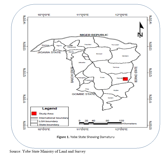
Damaturu town is located between latitude 11° 39’ 30’’ – 11° 47’ 00’’ N and longitude 11° 54’ 00’’ – 12° 02’ 00’’E in Yobe State in northeastern Nigeria as shown in Figure 1. The town was made the capital of Yobe State in 1991. The population of Damaturu is estimated at 69,952 in 2010 [6]. The major tribes in the area are the Fulani and Kanuri. Others are the Hausas, Karai- Karai, Bade, Igbo and Yoruba. The major occupations in the area are civil service and trading.
Methodology
Types and sources of data
The secondary data used for this study include base map of Damaturu town obtained from Yobe State Ministry of Land and Survey. The current population data and projections were obtained from National Population Commission. Other secondary data were obtained from Ministry of Land and Survey, Ministry of Works, and Ministry of Housing Development in Yobe State.
In estimating the future growth of Damaturu to 2030, linear regression statistics was used. Lopez et al. (2010)7 reported a model for prediction of landuse/landcover change in a typical Mexican city. They concluded that the Markov transition matrix is more useful at the descriptive rather than the predictive level; while linear regression between urban and population growth offered a more robust prediction of urban growth in the city. Hence, linear regression was adopted for this study. The Linear Regression is represented as follows:
Yt = f (T)
Where Yt = building density or urban land use expansion
T = time
Explicit for
Yt =λo + λ1 T
Where λo = constant
λ1 = coefficient of time
Results and Discussion
Future Scenario of Damaturu Urban Expansion (2009-2030)
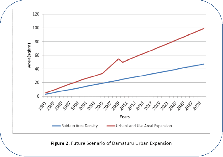
This section presents the projected future scenario of Damaturu urban expansion which is based on the urban growth rate of the town from 1991 to 2009. Findings revealed that Damaturu urban area will expand from 54.37Km2 in 2009 to 99.18Km2 by 2030 as shown in Figure 2. While the built-up density is estimated to increase from 23.42 Km2 in 2009 to 47.36 Km2 in 2030, depicting an expansion of 82% in urban area, as well as 102% increase in built up density.
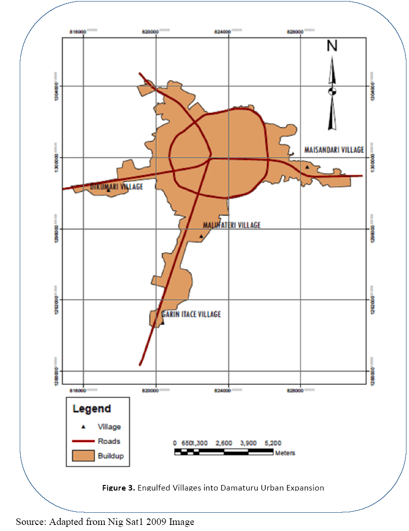
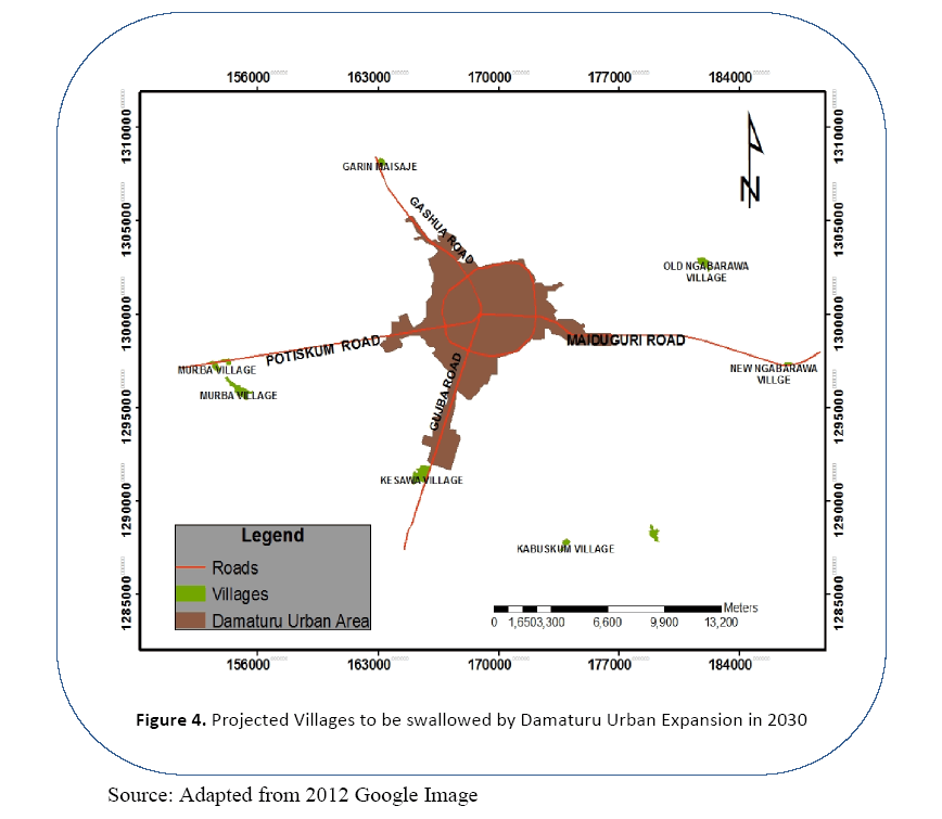
If the present growth scenario continues by 2030, Damaturu urban expansion will swallow up many nearby villages, some of which include Old and New Ngabarawa located along Maiduguri Road, which is about 10km away from Redbricks Housing estate. Others are Kesawa and Kabuskum villages located along Gujba Road; Garin-Maisaje, which is located about 6.5miles from Gahua Road; and Murba, which is about 9.3miles away from Postiskum Road as shown in Figures 3 and 4. The present bottleneck pattern of growth along main roads will soon engulf these villages.
However, this future growth scenario can only be attained if there is no crises and normalcy return to Damaturu town. There is no doubt that persistent crises in the town has affected the urban growth pattern, whereby people from traditional wards especially Pompomari, Ajiyari, Pawari, and Nayinawa migrated to Housing Estates and their Extensions. This is because the Housing Estates were not directly affected by the crises.
Conclusion
This study projected urban growth of Damaturu town from 2009 to 2030. Findings revealed that Damaturu urban area will expand by close to 50% over the period of study. While the built-up density will more than double over the period. If the present growth pattern continues by 2030, Damaturu urban expansion will engulf many close by villages. This projection can only be attained if there is no crises and normalcy return to Damaturu town. This future urban growth scenario can guide policy makers, urban and regional planners in proper planning and provision of future urban infrastructure in Damaturu town and its environs.
Recommendations
The following recommendations are worthwhile:
• Yobe State Ministry of Land & Survey should adopt modern planning techniques to be able to project future growth scenario.
• The physical growth of Damaturu should be directed along Gashua Road, because of the following reasons: Presently, the growth is largely towards Maiduguri Road which will soon push Damaturu town beyond Yobe State boundary. This will surely cause administrative problems and boundary disputes. Secondly, if the growth is directed along Potiskum Road and Gujba Road, there will be more ecological destruction as there is more vegetation along these axes than along Gashua Road.
• In addition, siting of housing estates and other growth pulls along the high ways should be avoided, in order to avoid linear bottleneck growth pattern.
Moreover, planning authorities should prepare and implement future development master plans for the town which should incorporate the future growth scenario.
References
- Rimal, B., 2011: APPLICATION OF REMOTE SENSING AND GIS, LAND USE/LAND COVER CHANGE. Journal of Theoretical and Applied Information Technology, 80 – 86.
- Al-Ghamdi, K., Mirza, M., EL Zahrany, R. and Dawod, G., 2012: GIS Evaluation of Urban Growth and Flood Hazards: A Case Study of Makkah City, Saudi Arabia. FIG Working Week: Knowing to manage the territory, protect the environment, evaluate the cultural heritage Rome, Italy, 6-10 May.
- Balogun, I. A., Adeyewa, D. Z., Balogun, A. and Morakinyo, T. E., 2011: Analysis of urban expansion and land use changes in Akure, Nigeria, using remote sensing and geographic information system (GIS) techniques. Journal of Geography and Regional Planning, Vol. 4(9), pp. 533-541.
- Jajere, A. A., Musa, I. J. and Isma’il, M., 2014: Geographical Determinants of the Structural and Functional Growth of Damaturu Town in Yobe State, Nigeria. Growth: Vol. 1, No. 1, 10-17.
- Jajere, A. A., Isma’il, M. and Musa, I. J., 2015: Analysis of Landuse/Landcover Change in Damaturu Town of Yobe State, Nigeria. Advances in Research, 3(1): 7-19.
- NPC (National Population Commission), 2006: Population Census Data, NPC, Abuja, Nigeria.
- Lopez, E., Bocco, G., Mendoza, M. and Duhau, E., 2001: Predicting Land Cover Land Use Change in the Urban Fringe: in Morelia City Mexico. Landscape and Urban Planning, 55(4), 271-285.
Open Access Journals
- Aquaculture & Veterinary Science
- Chemistry & Chemical Sciences
- Clinical Sciences
- Engineering
- General Science
- Genetics & Molecular Biology
- Health Care & Nursing
- Immunology & Microbiology
- Materials Science
- Mathematics & Physics
- Medical Sciences
- Neurology & Psychiatry
- Oncology & Cancer Science
- Pharmaceutical Sciences


