ISSN : 2393-8854
Global Journal of Research and Review
Qualitative Land Suitability Evaluation for Maize (Zea mais L.) in Abyek, Iran Using FAO Method
Department of Soil Science Engineering, University of Tehran, P, O, Box: 4111, Karaj 31587-77871, I, R, Iran
Abstract
In the recent study, land suitability evaluation for maize has been determined using FAO method in Abyek area, located in Qazvin province of Iran. This study was carried out for maize at Abyek area with 16618 ha. Soil and climate data were collected from 61 soil profiles at research farms and bagh kousar climatological Station, respectively. Maize growth of landscape, soil and climate requirements were determined using Sys et al tables and qualitative suitability classification of this crop was done by parametric square root method. The results showed that the study area climate was highly suitable for maize. Based on parametric square root method, 24.19% of the area S1, 37.28% S2, 29.53% S3, 5.26% N and 3.74% are NS for maize. In addition, soil depth, gravel percentage, lack of organic matter, salinity, alkalinity, and gypsum are important limiting factors in the area.
Keywords
Land suitability, FAO, Square root.
Introduction
Land suitability is the ability of a portion of land to tolerate the production of crops in a sustainable manner. The analysis allows identifying the main limiting factors of a particular crop production and enables decision makers to develop a crop management system for increasing the land productivity [1]. The FAO defined that The suitability is a function of crop requirements and land characteristics and it is a measure of how will the qualities of land unit matches the requirements of a particular form of land use [2]. Another definition describes the land suitability evaluation as a process, which predicts the land efficiency and application for certain types of uses over the time [3]. Albaji et al [4]. Investigated the land suitability for agricultural crops in the Abbas Plain, Southwest Iran. Qualitative evaluation was carried out by means of simple limitation and parametric methods (Storie and Root Square Method) and comparing land and climate characteristics with crop needs. Kandari et al [5]. Performed a land suitability evaluation for maize cultivation using GIS and used an FAO framework to determine the land suitability classes. The main objective of this study was to evaluate land suitability for maize based on parametric square root method in Abyek area located in Qazvin province of Iran.
Materials and Methods
Field description and soil sampling
The study area is located in Abyek area, located in Qazvin province of Iran, which covers an area of 16618 ha; between latitudes of 36° 00' and 36° 11' N and between longitudes of 50° 16' and 50° 20' E. The climate of the area is semi-arid with a mean annual rainfall of 258 mm and minimum and maximum relative humidity of 52 and 82%, respectively. The mean annual temperature is 14.1°C. The soil moisture and temperature regimes of the region by means of Newhall software are Weak Aridic and Thermic, respectively. Common agricultures in the region include fall growth of irrigated barley, wheat, maize and alfalfa. The agriculture in the area uses traditional to semi-mechanized techniques and equipment. After preliminary studies of topographic maps (1:25000), using GPS, studying location was appointed. 214 soil samples were collected from different horizons of 61 soil profiles located in the region.
Laboratory analysis
Physical and chemical properties of the sieved soil samples (<2mm) were determined after being air-dried. Particle size analysis by hydrometer method. Organic Carbon (OC) was determined using Walkley-Blackmethod6. The Clod method [7] was used to determine Bulk density (Bd).
The moisture contents at field capacity and wilting point were determined with a pressure plate apparatus [8] at-33 and-1500 kPa, respectively. Water saturation percentage (SP) was determined using Gravimetric method, CaCO3 content was determined using Calcimetry method, gypsum content was determined using Acetone method and CEC (cation exchange capacity in cmol ckg-1 soil) determined by the method of Bower [9]. pH, electrical conductivity (EC), dissolved Ca2+, Mg2+, Na+ and K+ were determined using standard methods [10].
Land suitability evaluation
In evaluating of the qualitative land suitability, land properties were compared with the corresponding plant requirements. In this stage, in order to classify the lands the parametric square root method was used Sys et al [11,12].
Parametric square root method
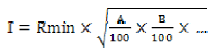
In this procedure, a quantitative scaling is assigned to each characteristic of the lands. If a specification is quite good for the intended crop, the maximum rate of 100 is assigned to it. If the same specification meets some limitations, a lesser rate will be assigned to it. The square root method, equation (1) can be used to acquire the land and climate index.
 (1)
(1)
I = Land and Climate Index
A, B, C,. = remaining ratings land characteristics.
Rmin = minimum rating land characteristics.
Then, using (Table. 1), the land suitability classes are determined.
Table 1. Land suitability classes based on land index in the parametric square root method
| Suitability classes | Index |
|---|---|
| Highlysuitable (S1) | 75-100 |
| Moderatelysuitable (S2) | 50-75 |
| Marginallysuitable (S3) | 25-50 |
| Unsuitable (N) | 0-25 |
Results and Discussion
After the interpretation of aerial photographs and analysis of experimental and morphological data, the study area was separated and defined into 24 soil units. Based on soil taxonomy (USDA, 2010) [13], this region has soils in Entisols, Enceptisols and Aridisols orders. (Fig. 1) shows the soil units map of the area. In this map, the soil units are shown with the numbers 1 to 24. On the map, the unit 10 is the largest unit with an area of 3378 hectares, while the unit 4 with an area of 114 hectares is the smallest unit. Some physicochemical characteristics for reference profiles of different soil units are shown in (Table. 2) The climate evaluation results show that the climate does not generally make much limitation for the cultivation of maize, and the climate suitability classes are Highly suitable (S1). Land suitability and climatic suitability classes for maize using parametric square root method are shown in (Table. 3) and land suitability map in (Fig. 2). Based on the below figures, about 4020 ha (24.19%) of land area are in class S1, 6196 ha (37.28%) in the class S2, 4907 ha (29.53%) in class S3, 875 ha (5.26%) in class N and 620 ha (3.74%) in the class NS (unstudied). Based on the results, the majority of soils in the central part of the region are in the S1 class. In the northern part of the region, including units 2, 3, 4, 5, 6, 7 and 8, the main limitations are presented of gravel and the Lack of organic matter. With crop residue management as well as adding organic matter to the soil, the crop yield in these units can be increased. In unit 18 in the southern part of the region, the high salinity of soil is considered as the main limiting factors, leading to class N of these unit. In units 1, 13, 15 and 16, the soil salinity and alkalinity content are effective in crop production, determining the suitability classes of these units in class S3. Behzad et al [4]. In the khuzestan Province also showed that the most limiting factors of the land suitability, in maize productions included physical characteristics such as soil texture, soil depth and lime content.

Figure 1: Soil unit's map of the study area

Figure 2: Land suitability map for maize using parametric square root method
Table 2. Some physicochemical properties of the soil units
| Soil units | Soil texture *(Class) |
Depth (cm) | Gravel (%) | Gypsum (%) | CaCO3 (%) | EC (dS/m) |
OC (%) |
|---|---|---|---|---|---|---|---|
| 1 | C | >90 | 0 | 13.3 | 16.39 | 3.11 | 0.41 |
| 2 | L | >90 | 25.5 | 0 | 17.21 | 7.02 | 0.42 |
| 3 | CL | >90 | 6.34 | 0 | 20.17 | 1.07 | 0.66 |
| 4 | L | 90 | 23 | 0 | 20.73 | 0.57 | 0.44 |
| 5 | C | 75 | 15.31 | 0 | 4 | 0.48 | 0.47 |
| 6 | SL | 20 | 35 | 0 | 3.84 | 0.59 | 0.50 |
| 7 | L | >90 | 12.92 | 0 | 12.30 | 3.09 | 0.68 |
| 8 | SCL | 35 | 34.8 | 0 | 3.86 | 0.99 | 0.25 |
| 9 | L | 85 | 12.79 | 0 | 8.93 | 0.72 | 0.75 |
| 10 | CL | >90 | 2.22 | 0 | 7.09 | 1.4 | 0.66 |
| 11 | C | >90 | 0 | 3.18 | 19.2 | 5.4 | 0.64 |
| 12 | C | >90 | 0 | 4.24 | 17.05 | 3.87 | 0.57 |
| 13 | C | >90 | 0 | 8.49 | 17.21 | 7.02 | 0.55 |
| 14 | C | >90 | 0 | 0.66 | 16.41 | 6.67 | 0.56 |
| 15 | C | >90 | 0 | 6.36 | 17.13 | 5.44 | 0.56 |
| 16 | C | >90 | 0 | 0 | 17.63 | 2.06 | 0.61 |
| 17 | C | >90 | 0 | 2.12 | 14.17 | 3.87 | 0.55 |
| 18 | C | >90 | 0 | 9.65 | 9.42 | 37.26 | 0.31 |
| 19 | C | >90 | 0 | 0 | 21.35 | 6.94 | 0.58 |
| 20 | CL | >90 | 7.5 | 0.33 | 16.02 | 1.06 | 0.70 |
| 21 | CL | >90 | 10.5 | 0 | 10.78 | 0.94 | 0.43 |
| 22 | SL | 50 | 36 | 0 | 2.6 | 0.65 | 0.39 |
| 23 | CL | 80 | 0 | 0 | 12.5 | 0.92 | 0.50 |
| 24 | L | >90 | 0 | 0 | 9.66 | 0.64 | 0.39 |
*C=Clay, L= Loam, C.L= Clay Loam, S.L= Sandy Loam, S.C.L= Sandy Clay Loam
Table 3. Land suitability classes for maize using parametric square root method
| Soil units | Climatic suitability classes | Land index | Suitability classes |
|---|---|---|---|
| 1 | S1 | 41.95 | S3s* |
| 2 | S1 | 46.50 | S3sf |
| 3 | S1 | 55.50 | S2s |
| 4 | S1 | 38.30 | S3s |
| 5 | S1 | 63.44 | S2s |
| 6 | S1 | 23.14 | N |
| 7 | S1 | 58.43 | S2sf |
| 8 | S1 | 37.50 | S3sf |
| 9 | S1 | 61.50 | S2s |
| 10 | S1 | 75.63 | S1 |
| 11 | S1 | 50.50 | S2f |
| 12 | S1 | 73.5 | S2nf |
| 13 | S1 | 45.47 | S3ns |
| 14 | S1 | 48.80 | S3ns |
| 15 | S1 | 47.15 | S3ns |
| 16 | S1 | 67.51 | S2s |
| 17 | S1 | 12.81 | N |
| 18 | S1 | 11.52 | N |
| 19 | S1 | 44.80 | S3ns |
| 20 | S1 | 77.50 | S1 |
| 21 | S1 | 67.80 | S2sf |
| 22 | S1 | 42.10 | S3s |
| 23 | S1 | 85.70 | S1 |
| 24 | S1 | 65.50 | S2sf |
*s, f and n represent the, physical properties of soil limitations, fertility limitations and salinity and alkalinity limitations
Conclusion
The land suitability analysis for agriculture is an important piece of information for agricultural development and future planning. This study was performed aiming at land suitability evaluation as an indispensable and crucial tool for land use planning as well as sustainable development in Abyek area, located in Qazvin province of Iran. Using interpretation of aerial photographs of the area as well as morphological properties and chemical and physical analyses of the region soils, 24 soil units were obtained. Land suitability assessment in each unit for the maize was performed using parametric square root method. The results showed that the climate properties make no limitations to the growth of the product. Regarding the restrictions on soil properties, the results showed that the central part of the area has a high suitability for maize cultivation, while in the northern part of the area, restrictions of gravel presence and Lack of organic matter are observed. In the southern part of the region, the limiting factors included the salinity and alkalinity content of the lands as well as the gypsum content of the soil.
References
- Halder J. Land Suitability Assessment for Crop Cultivation by Using Remote Sensing and GIS, J Geol, 2013, 5(3), 65–74.
- FAO. A framework for land evaluation.FAO Soil Bulletin, 1976, No 32. Rome.
- Sonneveld M, Broeke D, van Diepen A, Boogaard L. Thirty years of systematic land evaluation in the Netherlands, Geoderma, 2010, 84–92.
- Albaji M, Naseri S, Boroomand Nasab A, Papan P. Qualitative evaluation of land suitability for principal crops in the Abbas Plain, Southwest Iran. J Food AgricEnviron, 2009, 7(1), 208-213.
- Kandari A, Baja S, Ala A. Agro ecological zoning and land suitability assessment for maize (Zea mays L.) development in Button regency, Indonesia. Agriculture, Forestry and Fisheries, 2013, 2(6): 202–211.
- Nelson D, Sommers L. Total carbon,organic carbon, and organic matter. In A. L. Page, R. H. Miller, & D.R. Keeney (Eds.), Methods of Soil Analysis. Part II, 2nd Ed. American Society of Agronomy, Madison, WI. USA, 1982, 539-580.
- Blake G, Hartge K. Particle density. In A. Klute (Eds.), Methodsofsoil analysis. Part Agron. Monogr. 9. ASA. Madison, WI, 1986, 377–382.
- Cassel D, Nielsen D. Field capacity and available water capacity. In A. Klute, (Eds.), Methods of Soil Analysis. Part 1, second Ed. Agron. Monogr. 9. ASA and SSSA. Madison, WI, 1986, 901-926.
- Sparks L, Page A, Helmke A, Leoppert H, Soltanpour P,Tabatabai M, Johnston G, Summer M. Methods of soil analysis. Soil Sci. Soc. Of Am. Madison, Wisconsin.1996
- USDA. Field book for describing and sampling soils. Version 1.1, Lincoln: Nebraska. NRCS. 1998
- Sys C, Van Ranst E, Debaveye J, Beernarent F. Land evaluation. Part III: Crop requirements. International training center for postgraduate soil scientist. Ghent University, Ghent, 1993, 199 p.
- Sys C, Van Ranst E, Debaveye J. Land evaluation. Part I: Principles in land evaluation and crop production calculations. General Administration for Development cooperation. Agricultural Publisher. No. 7, Brussels, Belgium, 1991,274 p.
- USDA. Soil Survey Staff. Keys to Soil Taxonomy. 11 th edition. 2010 Behzad M, Albaji M, Papan P, Boroomand Nasab S. Evan region qualitative soil evaluation for wheat, barley, alfalfa and maize. J Food Agric Environ, 2009, 7 (2): 843-851.

Open Access Journals
- Aquaculture & Veterinary Science
- Chemistry & Chemical Sciences
- Clinical Sciences
- Engineering
- General Science
- Genetics & Molecular Biology
- Health Care & Nursing
- Immunology & Microbiology
- Materials Science
- Mathematics & Physics
- Medical Sciences
- Neurology & Psychiatry
- Oncology & Cancer Science
- Pharmaceutical Sciences