Keywords
SPI, SDI, Pearson correlation, Karaj Dam basin
Introduction
Drought has been identified as one of the environmental phenomena and in fact is an integral part of climate change
that can happen in any geographic area. The drought phenomenon has the various types of drought that divides to
meteorological, hydrological, and agricultural as well as socio-economic[16]. The first meteorological drought
occurs that refers to lack of rainfall. Meteorological drought led to a lack of soil moisture and agricultural production
as well as increases the risk of forest fires (agricultural drought).With its development hydrological drought occurs
when surface water flow scarcity and ground water relative to the normal condition.
Drought is a complex term that has various definitions, depending on individual perceptions e.g. in farmer’s
language “a shortage of rainfall or a long period of time without any rainfall”, or a period of below average rainfall or a prolonged period of dryness that can cause damage to plants. It may be categorized into different types e.g.
Meteorological, Hydrological, Agricultural and Socio-economic drought. The glossary of Meteorology defines
drought as a period of abnormally dry weather sufficiently prolonged for the lack of water to cause serious
hydrological imbalance in the affected area, on the degree of dryness and the duration of dry spell [8].
Although, many erroneously consider it a rare and random event but drought is a normal, recurrent feature of
climate. It can occur in virtually all climatic zones, with its characteristics varying significantly from one region to
another. It is an insidious hazard of nature. Drought is a reoccurring phenomenon in the northwestern part of
Bangladesh. Though the drought has attracted less scientific attraction than flood or cyclone, several authors found
that the impact of drought can be more defenseless than flood and cyclone [1].
Moradi and et al.[13] with use SPI and SDI study assessment of Meteorological and hydrological drought in
Khoram Abad basin. The results of the statistical analysis and comparison between SPI and SDI indices showed that
the dominant mode in this area is almost normal. Kashefi [10] to evaluate the temporal and spatial risk of drought
occurred in Semnan province used from SPI. The results showed that occurrence of drought in the region reveals
their effect immediate or one month delayed on surface water sources. Hedari [7] study Meteorological and
hydrological drought in the southwest of Iran. Their results showed that hydrological drought in the Urmia city with
a one-month delay and in Khoy city with a time lag of 2months, than meteorological drought has been occurrence.
Stability of Hydrological drought respectively three months and five months was determined after the event. Serrano
and Lopez study SPI drought in Spain to compare different time-scale with surface hydrologic variables. Their
research results showed that the overall surface flows with short periods of 1 to 3 month SPI and ground water
resources with longer periods of 7 to10 months are most correlated. This study aimed to investigate the relationship
between drought in different period to determine relationship between meteorological drought and hydrological
drought is done with using SPI and SDI in Karaj Dam basin.
Materials and Methods
Case study
Karaj Dam basin is partial of southern slopes of the Alborz Mountain in Northwest of Tehran province and located
between 51° 5̍ 38˝ until 51° 30̍ 57˝ east longitude and 35° 52̍ 56˝ until 36°11̍ 49˝ north latitude. This basin in divided
is a part of Salt Lake basin its areais778 square kilometers. The highest point in the area with an altitude of
4368meters in Dizin and the average height of basin is 2827 meters above sea level and drainage density equal to 7.1
km2.km. The lowest annual rainfall is for Karaj Dam station with 418.33 mm and the maximum is for Nesa station
with 667.43 mm. The climate of region is wet as well as precipitation regime in the region is Mediterranean type.
Average slope of the study area is about 43.84 percent. Most of the soils are litho soil and rego soil and soil depth in
more than half are shallow as well as pebbles. Soil texture in the study area is mainly sandy loam. The most land use
that can see in region is rangeland and forest.
Standardized Precipitation Index (SPI)
If the monthly rainfall time series of stations in area are referred to Pij in this i is hydrological year and j is months
of the hydrological year. Rainfall time series with different periods can be obtained using the following equation.
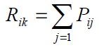

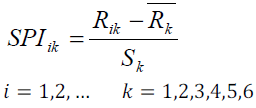
SPI based on high cumulative rainfall ( Rik ) for the basis period (k) Relating to(i) hydrological year is obtained as
following equation.
 and
and  is the mean height of cumulative rainfall and standard deviation cumulative rainfall for the based on k. Table 1showed the various modes of drought in SPI.
Standardized Discharge Index
In this study SDI is quite similar with SPI. In this method, assumed that the time series of monthly stream flow
volumes i is as that is hydrological year and j is months of the hydrological year. This series is based on the
following equation.
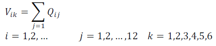
k is based on monthly. K values against 1, 2, 3, 4, 5, and 6 as well as respectively represent time periods 3, 6, 9, 12,
24 and 48 monthly. Standardized Discharge Index based on the cumulative volume of river flows  under for the
period k About I hydrological year is obtained following equation.
under for the
period k About I hydrological year is obtained following equation.
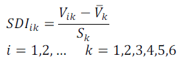
Respectively  and is mean total volume flow and standard deviation of cumulative flow volume for under
period k. Table 2 showed the various modes of drought in SDI.
and is mean total volume flow and standard deviation of cumulative flow volume for under
period k. Table 2 showed the various modes of drought in SDI.
To investigate the effects of drought on surface flow initially the relationship between rainfall and discharge were
studied in the area and calculated latency effect of rainfall on discharge. Then SPI and SDI in the sixth period
(3,6,9,12,24 and 48 monthly) study by pearson correlation method and separately was compared to the same sub
basin.
Results and Discussion
Initially to study the effect of drought on surface water resources determined deficient precipitation and then time
delay surface flow reduce than it was estimated. In order to investigate the relationship between precipitation and
surface water flow in Karaj dam basin of two methods Comparison rainfall weighted average with Sierra station
(Located in the basin output) and rainfall weighted mean comparison with discharge weighted average were used.
Results showed a significant relationship in the level of 99% there are between precipitation and surface water flow
and the highest correlation occurs between them in the same month or a one-month lag (table 3).
Table 3: Pearson correlation coefficients with different time delays
Comparison of the two methods showed no significant difference between the m and so the Sierra discharge station
at the outlet of the study area can be used as representative of the whole field (table 4).
Table 4: F-test for comparison between the two methods of rainfall and discharge
To investigate the relationship between meteorological and hydrological drought, weighted average of SPI and SDI
in the whole basin and the breakdown basin were compared with sixth time scale and was calculated pearson
correlation coefficient. Results showed that the highest correlation between SPI and SDI scale is in 3monthsso the
correlation is significant even at the 99%confidence level (table 5). Also, the results of Pearson correlation between
SPI and SDI shows that the highest correlation is related to Sierra station which can be attributed to the location of
the domain (table 6).
Table 5: Pearson correlation coefficient between SPI and SDI
Table 6: Pearson correlation coefficient between in sub basin
Conclusion
The results of this review is similar with the results of the research Moradi et al. (2009), Hedari et al. (2009) and
Mofidi et al. (2010). Review temporal discipline Meteorological and hydrological drought in region shows the
highest correlation occurs at 3-month intervals. So even at the 99% level is significant and with increasing time scale
the correlations of SPI and SDI decreased in region that results Conform with Mofidi et al. (2010). Correlation is
weak SPI48 which indicates that this time scale can’t describe hydrological drought as well as the surface flow. The
review showed that there is the highest correlation between the spatial discipline meteorological and hydrological
droughts in Sierra sub basin. The correlation between meteorological and hydrological drought in the Sierra station
can be linked to the location of rainfall and hydrometric stations.
References
- Shahid, S and Hazarika, M. K., 2010, Water Resource Management, 24, pp 1989–2006
- Benjamin, L.H. and A. Saunders., 2002, Int. J. Climatol. 22: 1571-1592.
- Doupigny-Girux, L.A.,2001, Journal of the American Water Resources Association. 37(3): 505-524.
- EnsafiMoghaddam, T.,2007, Iranian Journal of Range and Desert Research. 14(2): 271-288. (In Persian).
- Eslamian, S., A. Zarei and A. Abrishamchi.,2004, Journal of Agricultural Sciences and Natural Resources. 8(1): 37-27. (In Persian).
- Ghasemian, D., M. TaiySemiromi, J. Chezgy, M. Broghany and A. Tahmasebi.,2009,The analysis of relationship between meteorological and hydrological drought in North Khorasan province by used SPI indices. Second national conference on the effects of drought and its management strategies. 20 pp. (In Persian).
- Heidari, M., E. Farrokhi, S. Tnyan and B. Hesari.,2009, Analysis of meteorological and hydrological drought by the use of DIP software Areas to be studied: Urmia and Khoy. Fifth National Conference on Science and Engineering Iranian Watershed. 114 pp. (In Persian).
- Huschke, R.E., 1959: Glossary of Meteorology. Amer. Meteor. Soc., Boston,
- Kardvany, P.,2002, Drought and ways to deal with it in Iran, Tehran University Publications, Printing, 392 pp. (In Persian).
- Kashef, M.,2008, Risk zoning and management of drought-induced water shortages in the northern Semnan province. M.Sc. Thesis, Gorgan University of AgriSci and Nature Resour. 167 pp. (In Persian).
- McKee, T.B., N.J. Doesken and J. Kleist.,1993,The relationship of drought frequency and duration to time scales. Preprints, 8th Conference on Applied Climatology, 17-22 January. pp: 179-184.
- Mishra, A.K. and V.R. Desai., 2005, J. Stochastic Environmental Research and Risk Assessment (SERRA). 19(5): 326-339.
- Moradi, H., A. Sepahvand and M. Khazayi.,2009, Assessment of meteorological and hydrological drought by using the modified SPI index and SDI (Case study: watershed Khorramabad). Fifth National Conference on Science and Engineering Iranian Watershed. 117 pp.
- Nalbantis, I. and G. Tsakiris,2008, Water Resour. Manage: DOI 10.1007/s11269-008-9305-1.
- Richard, R. and A. Heim.,2002, American Meteorological society, Aug 2002, 1149-1165 pp.
- Shahid, S and Behrawan, H., 2008, Natural Hazards, 46, pp 391–413
- Sharma, T.C.,2000, Hydrol. Process. 14: 1279-1788.
- Sheikh, V. and A. Bahremand.,2009, Investigation on hydrological trends of Atrak river basin. Research report. Vice-Presidency of Research and Technology of Gorgan University of Agricultural Sciences and Natural Resources, Gorgan, 77 pp. (In Persian)
- Smith, K.,1998, Environmental hazards, Rutledge, New York. 79 pp.
- Szalai, S. and S.Z. Bella.,2004, SPI Index for monitoring of drought development in 2003. EMS Annual Meeting Abstracts. 1: 258.
- Tavakkoli, M.,2001, Flood hazard zonation and its characteristics in the middle section of the Atrak River basin. M.Sc. thesis in Watershed Management Engineering, Gorgan University of Agricultural Sciences and Natural Resources. (In Persian)
- Vicente-Serrano, S.M. and J.I. Lopez-Moreno.,2005, Hydrology and Earth System Sciences. 9: 523-533.